The North West links trail: Hoylake to Lytham
Nine links courses (built on sandy ground by the sea) run up this coast from Royal Liverpool at Hoylake to Fairhaven at Lytham: about 79 miles door to door by road, in three natural stops (Wirral, Southport and Lytham St Annes) rather than one long drive. Two crossings make the trail longer than it looks on a map: the Mersey between Hoylake and the Sefton coast, and the Ribble estuary between Southport and Lytham.
By Chris, Golf Metric · Updated 23 September 2026 · Facts checked 23 September 2026
The order
Driving north from the Wirral to the Fylde coast, in the order the roads actually take you, is Royal Liverpool, West Lancashire, Formby, Hillside, Royal Birkdale, Southport and Ainsdale, St Annes Old Links, Royal Lytham and St Annes, then Fairhaven. All nine are links courses (built on sandy ground by the sea), and all nine are members' clubs that take visitors by booking rather than on the day.
| Stop | Course | Town | From previous stop | Drive time |
|---|---|---|---|---|
| 1 | Royal Liverpool | Hoylake | start | - |
| 2 | West Lancashire | Blundellsands | 18.0 miles | 42 min |
| 3 | Formby | Formby | 7.8 miles | 19 min |
| 4 | Hillside | Southport | 6.1 miles | 16 min |
| 5 | Royal Birkdale | Southport | 0.3 mile | 7 min |
| 6 | Southport and Ainsdale | Southport | 2.1 miles | 6 min |
| 7 | St Annes Old Links | Lytham St Annes | 41.0 miles | 1 hr 13 min |
| 8 | Royal Lytham and St Annes | Lytham St Annes | 1.4 miles | 4 min |
| 9 | Fairhaven | Lytham St Annes | 2.0 miles | 7 min |
Door to door, that's around 79 miles of driving, not counting anything you do once you get to each car park. It isn't an even spread: the Southport cluster of Hillside, Royal Birkdale and Southport and Ainsdale sit inside 3 miles of each other, while the two crossings either side of that cluster account for most of the mileage.
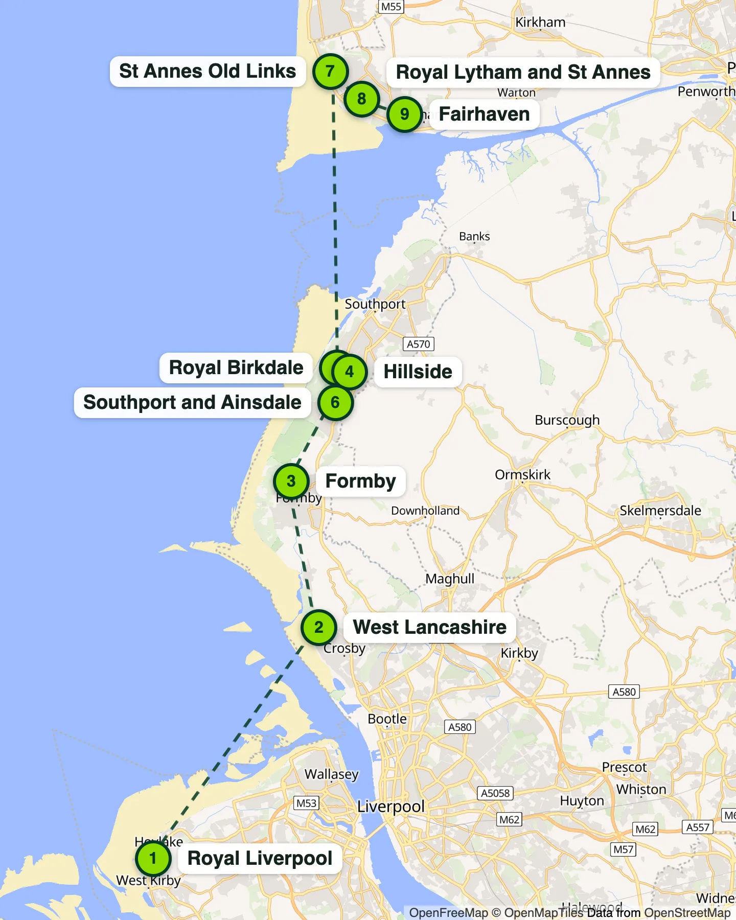
Two crossings make the trail longer than the map suggests
There's no bridge between Hoylake and the Sefton coast, and the Mersey Ferry doesn't carry cars, so the fastest route from Royal Liverpool to West Lancashire goes through a tolled Mersey tunnel: 18 miles and about 42 minutes on Google Maps' fastest route, against a straight-line distance of under 5 miles across the water. Check the current toll with Mersey Tunnels before you travel.
The bigger detour comes between the Southport cluster and Lytham St Annes. The Ribble estuary sits between the two, and there's no coast road across it, so the fastest route on Google Maps runs inland via the M55: 41 miles and over an hour, more than half the trail's total mileage for what looks like a short hop up the coast on a map.
Where to base yourself
Three towns cover the nine stops sensibly rather than one hotel for the whole trip:
- Hoylake or West Kirby, Wirral, for Royal Liverpool on its own before crossing the water.
- Southport, for West Lancashire, Formby, Hillside, Royal Birkdale and Southport and Ainsdale, five courses within about a 20-minute drive of the town.
- Lytham St Annes, for St Annes Old Links, Royal Lytham and St Annes and Fairhaven, all inside 2 miles of the town centre.
That's a three-base trip even though it's five separate golf clubs staying in the middle base; Southport itself sits roughly in the middle of that cluster, so a hotel there keeps every drive in that stretch under 20 minutes.
When to go
This coast plays firmest, calmest and longest-lit from around May to July, and the same clubs tend to charge the most for it; see the best time of year for links golf for the Met Office figures and real club prices behind that. If you'd rather save money than chase perfect conditions, autumn is the usual middle ground, and several of these clubs cut their green fees hardest over winter, when you're also more likely to meet a temporary green or a trolley ban; see temporary greens, trolley bans and preferred lies for what that means on the day.
For juniors and older golfers
A trail like this is a lot of driving and a lot of walking across several consecutive days. Building in a rest day, or dropping to one course every other day, keeps it enjoyable rather than a route march, particularly for younger legs still building stamina or older golfers managing their own pace over 18 holes of dune country.
Questions people ask
How many days do you need for the North West links trail?
Realistically one round a day, so four to five days for all nine courses, plus travel between them. Three of the nine (Hillside, Royal Birkdale and Southport and Ainsdale) sit within about 2 miles of each other in Southport, so a short, fit group could fit two rounds into one long day there if tee times allow, but that is not something Golf Metric has checked with any of the three clubs.
Can you turn up and play, or do you need to book ahead?
Book ahead. All nine are private members' clubs that take visitors on set days or by online booking, not walk-up pay and play. Each course's own Golf Metric page links to its visitor booking page; check current availability and any handicap requirement with the club directly before you plan a day around it.
Do you have to go through the Mersey Tunnel?
By road, yes, or a long way round via Runcorn. There's no bridge between Hoylake and the Sefton coast, and the passenger-only Mersey Ferry doesn't carry cars. Google Maps' fastest route between the two goes through a tolled tunnel; check current toll charges with Mersey Tunnels before you travel.
Why is the Southport to Lytham leg so much longer than the others?
The Ribble estuary is in the way and there's no coast road across it. Google Maps' fastest route goes inland via the M55, around 41 miles and over an hour, against 6 to 19 miles for every other leg on this trail.
Is Fleetwood part of this trail?
No. Fleetwood is a links course too, but it sits north of Blackpool, beyond Lytham, so it falls outside a Hoylake-to-Lytham trail. See its own page, Fleetwood, if you want to extend the trip further north.
Read next
Sources
- Google Maps, driving directions, CH47 4AL to L23 8SZ (Hoylake to West Lancashire), checked 23 September 2026
- Google Maps, driving directions, L23 8SZ to L37 1LQ (West Lancashire to Formby), checked 23 September 2026
- Google Maps, driving directions, L37 1LQ to PR8 2LU (Formby to Hillside), checked 23 September 2026
- Google Maps, driving directions, PR8 2LU to PR8 2LX (Hillside to Royal Birkdale), checked 23 September 2026
- Google Maps, driving directions, PR8 2LX to PR8 3LG (Royal Birkdale to Southport and Ainsdale), checked 23 September 2026
- Google Maps, driving directions, PR8 3LG to FY8 2LD (Southport and Ainsdale to St Annes Old Links), checked 23 September 2026
- Google Maps, driving directions, FY8 2LD to FY8 3LQ (St Annes Old Links to Royal Lytham and St Annes), checked 23 September 2026
- Google Maps, driving directions, FY8 3LQ to FY8 4JU (Royal Lytham and St Annes to Fairhaven), checked 23 September 2026
- Google Maps, driving directions, CH47 4AL to FY8 4JU, full route (Hoylake to Fairhaven), checked 23 September 2026
Spotted something out of date? Email chris@ai-metric.com and we will check it against the source.